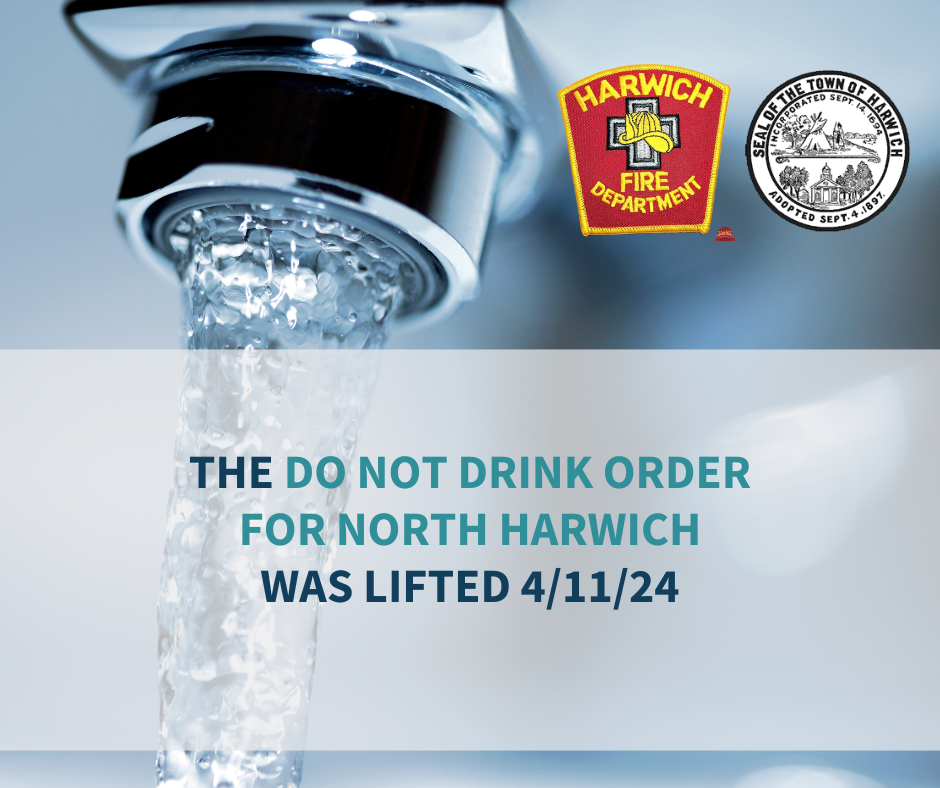
General
[9:00 AM] July 8, 2021 | Barnstable County Regional Emergency Planning Committee is on Alert for Tropical Storm Elsa
![[9:00 AM] July 8, 2021 | Barnstable County Regional Emergency Planning Committee is on Alert for Tropical Storm Elsa [9:00 AM] July 8, 2021 | Barnstable County Regional Emergency Planning Committee is on Alert for Tropical Storm Elsa](http://www.bcrepc.org/wp-content/uploads/2021/07/Copy-of-REPC-150x150.png)
Barnstable County Regional Emergency Planning Committee is on Alert for Tropical Storm Elsa Public asked to take safeguards as Elsa is expected to pass over southeast New England around dawn on Friday July 9. July 8, 2021 (Barnstable, MA) – Members of the Barnstable County Regional Emergency Planning Committee (BCREPC) held a conference call on Thursday […]
[3:30 PM] July 7, 2021 | BCREPC Continues to Monitor Tropical Storm Elsa
![[3:30 PM] July 7, 2021 | BCREPC Continues to Monitor Tropical Storm Elsa [3:30 PM] July 7, 2021 | BCREPC Continues to Monitor Tropical Storm Elsa](http://www.bcrepc.org/wp-content/uploads/2021/07/Picture1-150x150.jpg)
Incident or Event Overview Situation At 11:00am, Tropical storm Elsa was located 65 miles north-northwest of Cedar Key, Florida with 65 mph maximum sustained winds and a minimum central pressure of 999 mb. Elsa is moving north near 14 mph and will continue to move inland. There is still some uncertainty regarding Elsa’s exact track […]
[7:30 AM] July 7, 2021 | BCREPC Monitors Tropical Storm Elsa
![[7:30 AM] July 7, 2021 | BCREPC Monitors Tropical Storm Elsa [7:30 AM] July 7, 2021 | BCREPC Monitors Tropical Storm Elsa](http://www.bcrepc.org/wp-content/uploads/2021/07/power-outages-150x150.jpg)
Are you prepared? Although the sun is shining and we expect temperatures in the mid to upper 80s today on Cape Cod and the Islands, it is important to be prepared for Tropical Storm Elsa, likely to bring us 40 knot winds and potentially heavy and damaging rain later this week. Always #BePrepared for weather […]
[2:15 PM] July 6, 2021 | Severe Thunderstorm Watch Issued for Massachusetts
![[2:15 PM] July 6, 2021 | Severe Thunderstorm Watch Issued for Massachusetts [2:15 PM] July 6, 2021 | Severe Thunderstorm Watch Issued for Massachusetts](http://www.bcrepc.org/wp-content/uploads/2021/07/E5oQRNyUYAAHO-I-150x150.jpg)
A Severe Thunderstorm Watch has been issued by the National Weather Service until 8PM for most of Massachusetts (except for the Cape & Islands). A watch means thunderstorms are possible – be prepared. Storms may bring strong winds, hail and lightning. Read safety tips: http://mass.gov/mema/thunderstorms
[8:00 AM] June 30, 2021 | Oppressive Heat Continues/ Severe Thunderstorms Today
![[8:00 AM] June 30, 2021 | Oppressive Heat Continues/ Severe Thunderstorms Today [8:00 AM] June 30, 2021 | Oppressive Heat Continues/ Severe Thunderstorms Today](http://www.bcrepc.org/wp-content/uploads/2021/06/heat-6_30_21-150x150.png)
Strong to severe thunderstorms are expected today with an approaching cold front. The Storm Prediction Center (SPC) has placed much of state in the areas from Western to Eastern MA at enhanced risk for severe weather, Southeastern MA at slight risk, and the Cape and Islands at marginal risk. In terms of timing, thunderstorms are […]
[10:30 AM] June 7, 2021 | Heat advisories for Western, MA and Eastern, MA excluding the Cape and Islands and South Shore
![[10:30 AM] June 7, 2021 | Heat advisories for Western, MA and Eastern, MA excluding the Cape and Islands and South Shore [10:30 AM] June 7, 2021 | Heat advisories for Western, MA and Eastern, MA excluding the Cape and Islands and South Shore](http://www.bcrepc.org/wp-content/uploads/2021/06/heat-1-150x150.png)
Heat Advisory June 6th-8th The National Weather Service (NWS) has issued a heat advisory throughout most of the Commonwealth. The advisory is issued from Sunday 6/6 to Tuesday 6/8 with most of the region experiencing temperatures above 90 degrees. Temperature highs will be 90-95 degrees each day of the advisory with Monday 6/7 being the […]
[4:05 AM] May 28, 2021 | Gusty Winds and Heavy Rain for the Cape & Islands Tonight/Tomorrow
![[4:05 AM] May 28, 2021 | Gusty Winds and Heavy Rain for the Cape & Islands Tonight/Tomorrow [4:05 AM] May 28, 2021 | Gusty Winds and Heavy Rain for the Cape & Islands Tonight/Tomorrow](http://www.bcrepc.org/wp-content/uploads/2021/05/May-28_29-Gusty-Winds_Heavy-Rain-1-150x150.jpg)
Gusty Winds and Heavy Rain for the Cape & Islands Tonight and Tomorrow OVERVIEW: ▪Widespread 1-2” of rain which may be heavy at times ▪ Wind gusts up to 50 MPH over The Islands may cause power outages ▪ Hazardous marine conditions and some splash over along east coastal locations also a possibility TIMING: Heaviest […]
[3:30 PM] May 26, 2021 | Weather Update
![[3:30 PM] May 26, 2021 | Weather Update [3:30 PM] May 26, 2021 | Weather Update](http://www.bcrepc.org/wp-content/uploads/2021/05/may-25-REPC-150x150.png)
Scattered Strong to Severe Storms Possible Wednesday Afternoon and Evening [3:30 PM] May 26, 2021 | Update The most recent guidance suggests that the later timing of the development of storms in western MA should minimalize the impact to our region. The Barnstable County Regional Emergency Planning Committee will continue to monitor the situation. The […]
[9:15 AM] February 18, 2021 | Winter Weather Update – Snowfall Expected Today into Friday
![[9:15 AM] February 18, 2021 | Winter Weather Update – Snowfall Expected Today into Friday [9:15 AM] February 18, 2021 | Winter Weather Update – Snowfall Expected Today into Friday](http://www.bcrepc.org/wp-content/uploads/2021/02/1-150x150.jpg)
Thursday, February 18, 2021/ 9:15 AM – Snow in the southeast parts of the state will spread across the remainder of the state in the late morning or early afternoon today. Snow will continue through Thursday night into Friday that will range from 3-7 inches. Snow may mix with rain or sleet over southeastern Mass, […]
[3:15 PM] February 7, 2021 | Winter Weather Update
![[3:15 PM] February 7, 2021 | Winter Weather Update [3:15 PM] February 7, 2021 | Winter Weather Update](http://www.bcrepc.org/wp-content/uploads/2020/10/Map-1-150x150.png)
Most of the very warm air at the surface in coastal sections has been dislodged after the winds moved around to NNE and the column is rapidly cooling. Heavy snow is stacking up in many areas. Over the Cape/Islands, early warm temperatures prevented accumulation, but it should continue to accumulate now. Surface Low pressure continues […]
Follow Us!